About Xuyang Han
Master of Science
Modeling vessel behaviors by clustering AIS data using optimized DBSCAN. More than 3 years of well-rounded experience in geospatial data analytics using Python and other programming languages, big data in relational and non-relational databases, developing machine learning models (e.g., using TensorFlow), data mining, using software such as Tableau and GIS Online for data visualization and reporting insights.
Email me: han978@yorku.ca
Platforms

Research Project
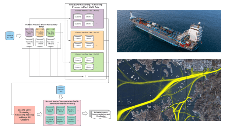
Modelling Vessel Behaviours by Clustering Marine Automatic Identification System (AIS) Data Using Optimized DBSCAN
Today, maritime transportation represents substantial international trade. Sustainable development of marine transportation requires systematic modeling and surveillance for maritime situational awareness. In this research, we present an enhanced density-based spatial clustering (DBSCAN) method to model vessel behaviors. The proposed methodology enhances the DBSCAN clustering performance by integrating the Mahalanobis Distance metric that considers the correlations of the points representing the locations of the vessels. The clustering method is applied to historical Automatic Identification System (AIS) data and generates an action recommendation tool and a model for detecting vessel trajectory anomalies.
Portfolio

Toronto Healthcare Query System
Esri Canada 2020 App Challenge. The App digitalizes Toronto Healthcare resources, and help the patients find the optimal healthcare nearby.

GIS and Advanced Spatial Analysis Project
Generate Residential Solar Panel Recommendation Map for City of Airdrie.

Carpooling Sharing Platform
Esri App Challenge 2019. Sustainability project, Build by ArcGIS API for JavaScripts.

CrimeSolutions Platform
Crowd-sourced crime reporting Platform. Full Stack Development using Django.
Publications
Xuyang Han, C. Armenakis, M. Jadidi, “DBSCAN OPTIMIZATION FOR IMPROVING MARINE TRAJECTORY CLUSTERING AND ANOMALY DETECTION”, ISPRS Archive, XXIV ISPRS Congress 2020, France.
Link | Presentation | Keywords: DBSCAN, Trajectory Clustering, Mahalanobis Metric, Machine Learning, Marine Transportation
